Canadian Train Bridges and Trestles
Train Bridges in The Maritimes
Join me on facebook so that you can keep up with all the changes to
this page and all the rest that make up Old Canadian Railways
Old Canadian Railways
Promote Your Page Too
| I decided to write this page on railway bridges after a visitor Arthur Grieve, Winnipeg, Manitoba offered to give me a number of railway bridge pictures that he had collected. I again hope that my visitors will be sending me their pictures to be included on this page. johnmacdonald@summerville-novascotia.com |
 | An ideal location to view some rail activity downtown Halifax is from the Young Avenue Bridge at the southern edge of the city, just past the classic railway station, which is worth a visit inside and out. While there is not a lot of rail power or rolling stock around, despite the vast rail network of former days, an SD40-2 switcher is likely to be around to gather a few loads around the Marginal Road area, along the South End Halifax Container Terminal (Halterm) and eventually bring the consist through the �railway cut�, constructed 97 years ago, specifically for the purpose. In this view, CN 5381 is passing under the Young Avenue Bridge on July 16th, 2010; enroute to another CN intermodal facility which will transport the cargo west. The tracks to the left, lead into the VIA station platforms. Trains travel infrequently along the cut but when they do, the consist passes under several bridges, the nearest two, being the Young Avenue Bridge and the Tower Road Bridge. Originally, there were 16. A guaranteed consist through the railway cut is the VIA train, to and from Montreal. Young Avenue is fairly busy, so expect a bit of noise but there is a very adequate sidewalk to take pictures from. |
| This picture was taken and submitted by Massey F. Jones | |
 | Tower Road Bridge, a couple of blocks away from Young Avenue, is another location which will bring rewarding rail observations, particularly when VIAtrains arrive and depart Halifax, as the consist passes under the bridge. It is also the beginning of the “Railway Cut”,started about August 1913, which was eventually spanned by 16 bridges, most of which today require fairly extensive repair; 6 of which now having tonnage restrictions. Crowds gathered on the Young Avenue Bridge December 22, 1918, to see the first Maritime Express of the Intercolonial Railway Company (ICR),steam through with perhaps red “ten wheeler” made in Liverpool, while passengers were awed at the rock walls looming above them. Rail traffic through the cut right now is infrequent and there is a study going on, about widening the cut and placing a roadway alongside the tracks. Some part of the study suggests that the tracks should be removed altogether and replaced by pavement for truck traffic into the Halterm container terminal. Another alternative is to imbed the CN tracks into the pavement. The disadvantage of taking photos looking into the harbor from the Tower Bridge is that there is a large pipe on a structure in the way but it doesn�t block the view very much (see the Young Avenue photo). Crossing to the other side, the view into the railway cut looking west is pristine, as shown in another view on this page.. Photo: Massey F. Jones |
| This picture was taken and submitted by Massey F. Jones | |
 | When VIA #14 train arrives from Montreal, the locomotive is near the station and it is necessary to have the whole train turned around for the next day’s departure. Rather than have a switcher do the work, it is done by the train�s motive power. The operation takes about 30 minutes. The first step is to back the train, observation car first, out of the VIA station and into the railway cut past a specific spot (described elsewhere). This will put the locomotives in the proper direction for the next move. After setting a turnout (switch); the train now moves forward under Tower Bridge Road and Young Avenue, then along Marginal Road within the South End Container Terminal (view the Google Earth photo), and then clockwise around a balloon track. After re-emerging from the balloon track, it again passes under Young Avenue and then Tower Road and proceeds well into the railway cut, stopping at a specific point, in the view shown here on July 16th, 2010. After a turnout is set; the train is then backed up, observation car first, into the VIA station, to the platform, where it will depart at Train #15 to Montreal, the following day. Operations were cut back in October 2012, from 6 times per week to 3 times per week. VIA train #14 (Ocean) arrives from Montreal on Thursday, Saturday and Monday and departs Halifax on Tuesday, Friday and Sunday. A trip takes about 23 hours with one time zone change. There are several classes of accommodation available and “Renaissance” cars used during the high season. The trains are also longer. Massey posted a 12-minute video clip on YouTube, showing the departure of VIA Train #15, followed by the arrival of VIA Train #14 into Halifax and then documents the major aspects of the switching operation described above. http://www.youtube.com/watch?v=LRDxrcUSeXs |
| This picture was taken and submitted by Massey F. Jones | |
 | A 2014 Google Earth view of the tracks, around the VIA station (top right ) and Halifax South End Container Terminal. The balloon track lower right, helps turn the VIA train around to have it face the proper way for departure. Despite the great amount of track, rail traffic is minimal now. The location of the Young Avenue and Tower Road bridges can be clearly seen. |
| This picture was taken and submitted by Massey F. Jones | |
 | The first bridge to span Halifax Harbour. Built in 1815 and finally distroyed in 1893 after being rebuilt in 1891. At that time it was destroyed by a fierce gale. |
| From Facebook group, Nova Scotia Memories of Days Gone By | |
 | CNR Sackville River Bridge, Bedford NS |
| This picture was taken by John MacDonald | |
 | An Old CNR Steam Engine crossing the CNR Bridge in Bedford NS |
| Posted on the Internet by the Nova Scotia Archives |
 | Location of the Midland Railway ((DAR) (Dominion Atlantic Railway) Bridge crossing the Shubenacadie River at South Maitland, Nova Scotia. This bridge is now used as a observation platform for the tidal bore on this river. The tide on this river raise over 45 ft. twice a day and cause a bore or wall of water that races up the river. |
| I | |
 | In 1901 the Midland Railway opened its line across Hants County, connecting Truro to Windsor and the Dominion Atlantic Railway through the Annapolis Valley. In 1912, the DAR purchased the Midland line. The DAR abandoned this line in the late 1970’s |
| I | |
 | The Midland Railway ((DAR) (Dominion Atlantic Railway) Bridge crossing the Shubenacadie River at South Maitland, Nova Scotia. |
| Posted on facebook by Youcef Amine | |
 | CNR River John Train Bridge |
| I | |
 | CNR Bridge, River John, Nova Scotia This bridge is on the abandoned Oxford Junction to Stellarton (Oxford Subdivision) |
| This picture was taken and submitted by Greg Evans | |
 | CNR Bridge, River John, Nova Scotia This bridge is on the abandoned Oxford Junction to Stellarton (Oxford Subdivision) |
| This picture was taken and submitted by Greg Evans | |
 | CNR Bridge, River John, Nova Scotia |
| This picture was taken and submitted by Greg Evans | |
 | CNR Bridge, River John, Nova Scotia |
| This picture was taken and submitted by Greg Evans | |
 | CNR Bridge, River John, Nova Scotia Sandstone bridge piling |
| This picture was taken and submitted by Greg Evans | |
 | CNR Bridge, Wallace River, Nova Scotia This bridge is on the abandoned Oxford Junction to Stellarton (Oxford Subdivision) |
| This picture was taken and submitted by Greg Evans | |
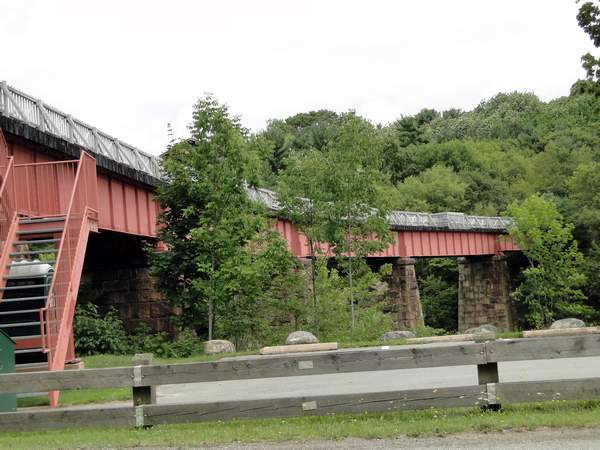
 | Rail Trestle, Westville NS mile 74.5 on what used to be the CNR Oxford Sub It is now the CBCNS Oxford Spur, May 2007 |
| This picture was posted as “Public domain” on Photobucket by Brian Hiscock | |
 | Rail Trestle, Westville NS mile 74.5 Deck |
| This picture was posted as “Public domain” on Photobucket by Brian Hiscock | |
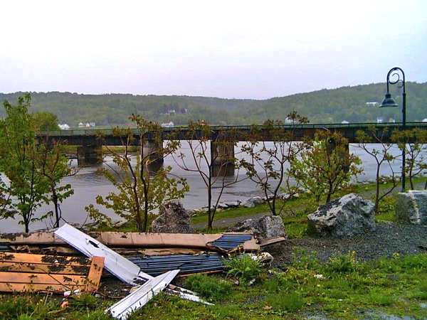
 | CN Rail Bridge of the Nine Mile River, Elmsdale NS Viewed from the #2 Highway bridge. This bridge was built by the Intercolonial Railway in the late 1850’s |
| This picture was taken by John MacDonald May 29, 2015 | |
 | CN Rail Bridge of the Nine Mile River, Elmsdale NS |
| This picture was taken by John MacDonald May 29, 2015 | |
 | This bridge is on the Dartmouth Musquodoboit Subdivision of the Canadian Government Railway. The bridge crosses a small stream on his property in Middle Musquodoboit. There once were tanks embedded along side the tracks for emergency water supply for the steam locomotives. This rail line ran from Dartmouth to Upper Musquodoboit. It is just 1/2 mile south of his residence and is still in good condition. |
| This picture was submitted by Lyle Bates, Middle Musquodoboit, Nova Scotia | |
 | Roadway bridge over the main line to the CN yard, Truro Nova Scotia and the branch line to Cape Breton NS (CBNS) Cape Breton and Central Nova Scotia Railway |
| I | |
 | Salmon River Railway Bridge, Truro Nova Scotia |
| This bridge is on the main CN line in Truro Nova Scotia | |
 | Foot Bridge over the ( CBNS ) Cape Breton and Central Nova Scotia Railway, Salmon River, Nova Scotia |
| I | |
 | Foot Bridge over the ( CBNS ) Cape Breton and Central Nova Scotia Railway, Salmon River, Nova Scotia |
| I | |
 | DAR Bear River, Nova Scotia Train Bridge |
| This bridge is on the abandoned DAR line | |
 | DAR Bear River, Nova Scotia Train Bridge This bridge has now been completely removed |
| This bridge is on the abandoned DAR line | |
 | DAR Blue Beach Road bridge |
| This bridge is on the abandoned DAR line | |
 | DAR Gaspereau River Bridge |
| This bridge is on the abandoned DAR line near Grand Pre Nova Scotia | |
 | DAR Gaspereau River Bridge |
| This bridge is on the abandoned DAR line near Grand Pre Nova Scotia | |
 | DAR Bridge Annapolis Royal Nova Scotia crossing Allains Creek |
| This bridge is on the abandoned DAR line near Annapolis Royal Nova Scotia | |
 | DAR Bridge Bridgetown, Nova Scotia |
| This bridge is on the abandoned DAR line in Bridgetown, Nova Scotia | |
 | The Pentz Lake Causeway near Mount Uniacke, NS This line has been taken over by the Windsor & Hantsport Railway Company. This company purchased what remains of the DAR from New Minas to Mantua with a branch to Windsor Junction. Since gypsum production has ceased in the Windsor area this line sees very little traffic. |
| This causeway is on the abandoned DAR line near Mount Uniacke, Nova Scotia | |
 | The Pentz Lake Causeway near Mount Uniacke, NS |
| This causeway is on the abandoned DAR line near Mount Uniacke, Nova Scotia | |
 | This bridge is on an almost abandoned DAR line near South Uniacke, Nova Scotia |
| This picture was taken by John MacDonald | |
 | This bridge is on an almost abandoned DAR line near South Uniacke, Nova Scotia. It crosses high over the Sackville River. |
| This picture was taken by John MacDonald | |
 | This bridge is on an almost abandoned DAR line near South Uniacke, Nova Scotia. It crosses high over the Sackville River. |
| This picture was taken by John MacDonald | |
 | The DAR Railway bridge and the highway bridge over the Avon River at Windsor Nova Scotia, 1940’s Heading east. The first railway bridge was built across the Avon River in 1870 and lasted until 1915 when it was replaced with this bridge the was in service until into the 1960’s when it was replaced by the present causway |
| Image courtesy of Nova Scotia Archives and Records Management, Halifax, N.S. | |
 | The DAR Railway bridge and the highway bridge over the Avon River at Windsor Nova Scotia Heading west |
| This picture was taken from a picture hanging in a local service station in Brooklyn NS | |
 | ICR Bridge over the Folly River A real early example of a train trestle of that period |
| Government of Canada Archives | |
 | CN Folly Lake Railway Bridge |
| This bridge is on the main line from Halifax to Montreal and crossed Highway 4 at Folly Lake | Posts ended here Dec1 2016 |
 | CN Bridge Waughs River, Tatamagouche, Nova Scotia |
 | CN Bridge Waughs River, Tatamagouche, Nova Scotia |
 | CNR Pattersons Wharf Road Overpass, Tatamagouche, Nova Scotia |
 | CNR French River Bridge, Tatamagouche, Nova Scotia |
 | DAR Train Bridge, Paradise, NS |
| This bridge is on the abandoned DAR line near Paradise, NS | |
 | DAR Train Bridge, Paradise, NS |
| This bridge is on the abandoned DAR line near Paradise, NS | |
 | CNR Roseway River Bridge near Shelburne, Nova Scotia This bridge is abandoned and is now part of a hiking trail It is comprised of two sections joined by a small island. The second section is shown below. |
 | CNR Roseway River Bridge |
 | CNR Tusket River Bridge |
 | CNR Tusket River Bridge shown from the new highway |
 | CNR Gold River Bridge , 1960’s |
| This picture was taken at the Halifax & Southwestern Railway Museum, Lunenburg Nova Scotia | |
 | Halifax & South Western Railway ( Canadian Northern Railway (CNR)) Martins River Bridge |
| Thise picture was taken by John MacDonald | |
 | Halifax & South Western Railway ( Canadian Northern Railway (CNR)) Martins River Bridge |
| Thise picture was taken by John MacDonald | |
 | Halifax & South Western Railway ( Canadian Northern Railway (CNR)) Bridge above Cooks Falls, Bridgewater, Nova Scotia This bridge is now part of a walking trail system |
 | Halifax & South Western Railway ( Canadian Northern Railway(CNR)) Bridge above Cooks Falls, Bridgewater, Nova Scotia This bridge is now part of a walking trail system |
 | Cooks Falls, Bridgewater, Nova Scotia |
 | Halifax & South Western Railway ( Canadian Northern Railway(CNR)) Bridge above Cooks Falls, Bridgewater, Nova Scotia This picture is looking east at the railway bridge over the Lahave River just above bridgewater. The picture was taken during construction of the bridge around 1903-04 |
| This picture was taken at the Halifax & Southwestern Railway Museum, Lunenburg Nova Scotia | |
 | Halifax & South Western Railway ( Canadian Northern Railway(CNR)) Bridge above Cooks Falls, Bridgewater, Nova Scotia This picture shows the bridge after completion. This view is from the east bank looking west. Notice how the bridge was built through the cented of a lumber mill that was situated on the west bank of the Lehave River. |
| This picture was taken at the Halifax & Southwestern Railway Museum, Lunenburg Nova Scotia | |
 | The Moncton CN (Pink) Subway 1960’s Pink Subway For a while the Subway was painted Pink and covered with local artwork. Every year main street would close and local artists and students would paint it. |
| CREDIT: Armand Melanson | |
 | This Dawson settlement trestle over Hiram Creek was built by The Albert Railway Company. Construction began in 1875 and in 1877 the line from Hillsborough to Albert was opened. In 1900 the line between Salisbury and Albert was purchased by the Dominion of Canada and operated by the Intercolonial Railway (which eventually became part of CN). This trestle was last used by the Salem & Hillsborough Railroad between 1984 and 1996 as a tourist railway carrying passengers and there was a dining car at selected times. This trains ran between Hillsborough, Salem & Baltimore, New Brunswick. The Salem & Hillsborough Railway is now operated by the New Brunswick Railway Museum. It is my understanding that this trestle has been removed in early 2012. |
| This picture was posted on Facebook by Judy Lynn Carson, Moncton NB | |
 | NR Tantramar River Bridge, Sackville NB This bridge carries all the CNR traffic from Montreal to Halifax |
| Taken by John Macdonald, Aug 16, 2015 | |
 | The “Saint John River Railway” Bridge at Centerville NB |
| This picture was taken and submitted by Sarah Levy | |
 | CPR Bridge Woodstock NB July 2007. This Bridge was taken out by ice in 1976 but was replaced shortly after that. It was finally taken out of service in the early 1990s |
| This picture was posted as “Public domain” on Photobucket by Brian Hiscock | |
 | CPR Trestle just west of the town of Woodstock crossing The Saint John River July 2007 |
| This picture was posted as “Public domain” on Photobucket by Brian Hiscock |
 | The CNR Doaktown Train Bridge The piers in the forground are from the old highway bridge which was removed in the late 1960s-early 1970s |
| This picture was take by Darlene Carvell-robichaud, Doaktown NB | |
 | The longest CNR rail bridge in Atlantic Canada stretches over the Salmon river where one can literally see a train float across the sky.It is located near New Denmark, New Brunswick. July 2007 |
| This picture was posted as “Public domain” on Photobucket by Brian Hiscock | |
 | The longest CNR rail bridge in Atlantic Canada stretches over the Salmon river where one can literally see a train float across the sky.It is located near New Denmark, New Brunswick. July 2007 |
| This picture was posted as “Public domain” on Photobucket by Brian Hiscock | |
 | Salmon River Valley Trestle on the CN mainline between Plaster Rock and Grand Falls NB This trestle is 3920 feet long and 195 feet high For more information on this trestle go to this web site http://blog.traingeek.ca/2007/12/bridges |
| This picture was submitted by Ed Anderson, Belleville, ON, Formerly of Plaster Rock, NB This picture was taken around 1983 | |
 | Salmon River Valley Trestle on the CN mainline between Plaster Rock and Grand Falls NB |
| This picture was submitted by Ed Anderson, Belleville, ON, Formerly of Plaster Rock, NB This picture was taken around 1983 | |
 | CNR Bridge Chipman NB crossing the Salmon River |
| This picture was posted as “Public domain” on Photobucket by Brian Hiscock |